The Boy Travelers - Africa by Thomas W. Knox Boy Travelers-Africa by Thomas W. Knox    

Chapter 21: The Plateau of Central Africa. Explorations of the Niger.

lesson image
Sunset on Lake Tchad


While they were at dinner, on the second evening after leaving Foueira, the conversation naturally turned upon the peculiarities of the region they were traversing.

"It is only within the present century," said the Doctor, "that we have definitely ascertained the geography of the interior of Africa. It was formerly supposed to be a mountainous region, sloping steadily away to the sea; and there was a tradition, as I have before told you, of the great rivers of Africa rising near each other and flowing in different directions, as the water is carried from the roof of a house.

"The explorations of Livingstone, Burton, Speke, Du Chaillu, Cameron, Baker, and others have demonstrated that the center of the continent is a vast plateau, or tableland, elevated from two thousand to four thousand feet above the level of the sea. There are mountains in the center, and in various parts of this plateau, eight or ten thousand feet high, and there is a rocky rim or edge nearly all the way around it, with occasional openings, through which the rivers find their exit."

Frank was pushing aside his tea saucer, when the Doctor paused and told him to invert it on the table.

"Now," he continued, "you have in that tea saucer, bottom upward, a fairly good picture of the interior of Africa. Let the table where it is lying represent the ocean surrounding the continent. The rim on which it rests when right-side-up is the mountainous ridge enclosing the central plateau, and the space in the center is the plateau, or tableland. The slope from the ridge to the edge of the saucer is the strip of land around the coast. It varies greatly, as it is very narrow in some parts of the continent and quite broad in others. If you break a few notches at irregular intervals along the ridge you will indicate the depressions where the rivers pass from the equatorial basin to the great ocean."

Frank was about to make the notches suggested by the Doctor, and thus complete the model of the African continent; but he was checked by Fred, who suggested that they were a long way from their base of supplies, and tea saucers could not be easily replaced. The practical illustration was consequently deferred indefinitely.

"It is in the central basin," Doctor Bronson farther explained, "that we find the great lakes which form the sources of the Nile, the Livingstone, and the Zambesi."
Scene on the Niger at Say

"How about the Niger?" Frank asked. "Does it come from the same basin, or does it have another origin?"

"The source of the Niger," replied the Doctor, "is far to the north of the great basin where the three rivers I have named have their origin. Thus far no European has seen the source of the Niger; it has been most nearly reached by Winwood Reade, who visited the stream at a point where it was not more than a hundred yards in width, and probably forty or fifty miles from where it has its beginning.

"The Niger was partially explored by the brothers Lander, Richard and John, in 1830 and 1831; they visited it again in 1832 and 1834, and endeavored to establish trade with the natives along the lower part of the river, and also on its tributary, the Benoowe. The latter stream is sometimes called the Chadda, or Tchadda, as it is supposed to rise in Lake Tchad; but whether it does so or not is not fully established. The Niger is properly formed by the junction of the Chadda and the Joliba, the latter being the more western, and pronounced by those who have seen it to be longer and larger than the Benoowe."

One of the boys asked if any other Europeans than the Landers and Mr. Reade had explored the valley of the Niger.

"Yes," was the reply. "In its lower course, it has been examined by so many that the names would make a long list. Near the end of the last century it was visited by Mungo Park, who was the first explorer of the upper valley of the Niger, and he went there again in 1805. Unfortunately for science, he was killed in this second expedition, and his papers were lost with him. In 1828 a Frenchman named Chaillié sailed down the river from Jenne to Timbuktu, and reached Europe in safety. His account supplied the deficiency left by the death of Park; and in 1853 Timbuktu was visited by Dr. Barth, a German traveler, who explored the river from that city to the town of Say, which lies in latitude 13° 8' south, and longitude 2° 5' east.
View of Kabara, the Port of Timbuktu

"Barth has left the account of his travels in three large volumes, which were published in 1857, and described his wanderings from 1849 to 1855. He died in Berlin in 1865, and is justly regarded as one of the famous explorers of Africa. His account of Timbuktu is the best that has reached us. He had a good opportunity to see the city, as he was detained there nearly a year by the Sultan, who refused to let him go on.

"The aggregate length of his journeyings was some fourteen thousand miles, and the territory he opened to the knowledge of the civilized world may be roughly estimated at four million square miles. He explored Lake Tchad and a considerable portion of the valley of the Niger, settled several questions that were troubling the geographers, and made a large addition to the knowledge of the Great Desert of Sahara.

"We are wandering from the equatorial basin of Central Africa," continued the Doctor; "but while on this subject we may as well have a peep at Timbuktu. We must make it in imagination, as there is very little prospect that any of us will ever get there in person. The French are talking about a railway from the Mediterranean to Timbuktu, and they also propose an inland sea by cutting a canal to flood the depression of the Sahara desert. Timbuktu would be near the southern shore of the proposed sea; but thus far the scheme has ended in nothing but talk. When the railway is completed, or the lake is formed, we will think about seeing the city, if, happily, any of us are alive.

"Timbuktu had been heard of for centuries, but the first European to visit it was Major Laing, in 1826. Chaillié went there in 1828, and Barth in 1853; and, as I before told you, the latter has given us the best account we have had of the city.

"Timbuktu is smaller than you might suppose from its age and celebrity. It has a population of about twenty thousand, which is largely increased at the time of the season of trade, between November and January. The city is a collection of huts of wood or stone, and there are few buildings of more than one story in height. There are three great mosques and several smaller ones. The largest of the mosques rises in the shape of a pyramid, with a broad base from the southwestern corner of the town.
Timbuktu from the Terrace of the House Occupied by Dr. Barth

"Dr. Barth was not permitted to go inside the mosque; but he probably did not miss much, as the native accounts of it represent the interior to be quite plain and without ornament. The town is about nine miles from the banks of the Niger. Its port is called Kabara, and is on a sandy hill, sloping down to the river. There is a broad basin for boats at Kabara, which Dr. Barth thought might be artificial, but was unable to ascertain whether it was so or not.

"The trade of Timbuktu is chiefly by caravans to Morocco, Algiers, Tunis, and Tripoli. Ghadames, about three hundred miles southwest of Tripoli, is the most important outlet for the products of Timbuktu, and the most southerly point to which travelers may venture without great risk.

"The population of Timbuktu comprises both Africans and Arabs, the latter coming from the desert regions to the north. All are highly devout Muslims, and for this reason the life of a Christian is not safe in the city if his religion is known. The few Europeans who have been there went in disguise, and Dr. Barth said his life would have been at risk if it had been known that he was anything but a Muslim."

Here Doctor Bronson was called from the tent by Abdul, who wanted advice about serving out provisions to the porters. Frank and Fred being left to themselves, the conversation took a lighter turn, though it did not leave the strange city they had been hearing about.

"It has been said," Frank remarked, "that the word 'Timbuktu' has no corresponding rhyme in our language."

"Haven't you heard," said Fred, "the rhyme that somebody once made for it? Here it is:

"'If I were a cassowary,

On the sands of Timbuktu,

I'd eat a missionary—

Eat his bones and hymn book too.'"

"I think I can make another rhyme for it," responded Frank. "You remember the Buck brothers, that spent a summer in our town once, don't you?"

"Yes," replied Fred, "I remember them well; one was short and stout, and the other tall and slim."

"Exactly so. Now, how'll this do?

"Just see how soon I write down

A rhyme for Timbuktu:

We had at one time in our town

Stout Buck and Slim Buck too."

"Very good!" exclaimed his cousin. "But I can do as well as that without half trying. Wasn't President Buchanan sometimes called 'Old Buck,' by way of familiarity?"

"I believe he was," Frank answered.

"That being the case," said Fred, "he will do for a rhyme like this:

"To James Buchanan came a letter

From the King of Timbuktu:

That monarch said, 'I can't do better

Than write Old Buck and Jim Buck too.'"

"That will do," was the response; "and here's another to match it:

"Sim and I went to the races,

By the coach from Timbuktu:

When we went to book our places

I said to him, 'Please, Sim, book two. '"

Fred tried to compose something else on the subject, but the power of rhyming left him, and he gave up the attempt just as the Doctor returned from his conference with Abdul.

    The Boy Travelers - Africa by Thomas W. Knox Boy Travelers-Africa by Thomas W. Knox    

Chapter 21: The Plateau of Central Africa. Explorations of the Niger.

Directions

Study the chapter for one week.

Over the week:

  • Read and/or listen to the chapter.
  • Review the vocabulary terms.
  • Complete the enrichment activities.

Vocabulary

Plateau: A largely level expanse of land at a high elevation.
Tableland: A relatively flat region of terrain, particularly in reference to surrounding terrain.
Equatorial: Of, near, or relating to the equator.
Basin: an area of land from which water drains into a common outlet.
Mosque: A place of worship for Muslims.
Timbuktu: A city in central Mali in Africa.
Cassowary: A large flightless bird native to Australia and New Guinea, has a characteristic bony crest on its head, and can be very dangerous.

Enrichment

Activity 1: Narrate the Chapter

  • Narrate the events aloud in your own words.

Activity 2: Study the Chapter Pictures

  • Study the chapter pictures and describe how each relates to the story.

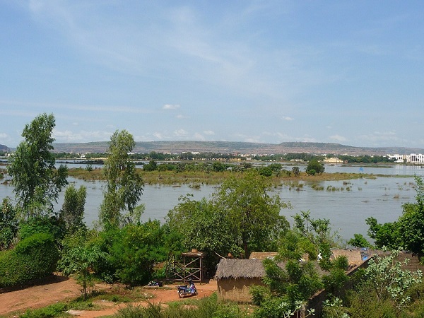
Activity 3: Observe the Modern Equivalent

  • Examine the chapter setting in modern times: The Niger River in the African country of Mali.

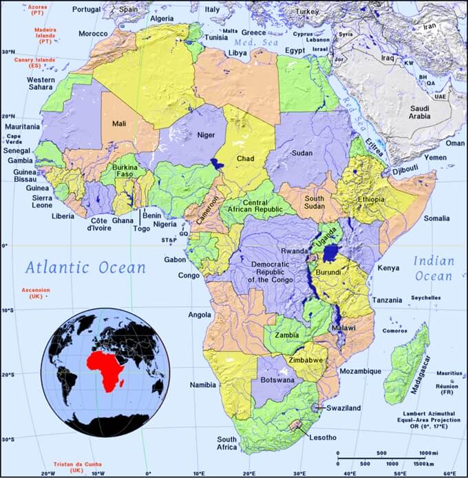
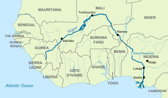
Activity 4: Map the Chapter

Find the countries of Sierra Leone and Nigeria on the map of Africa.

Find the countries of Sierra Leone and Nigeria on the map featuring the Niger River.

  • Find the Niger river and name the countries through which is passes.
  • Into which ocean does the Niger River empty?

Activity 5: Map the Chapter on a Globe

  • Repeat the applicable mapwork from Activity 4 on a three-dimensional globe.

References

  1. 'Map Showing Niger River by Hel-hama (CC BY SA 3.0).' Wikimedia Commons. commons.wikimedia.org/wiki/File:Map_of_River_Niger.svg. n.p.